Looking for gold deposits using publicly available satellite images
A convenient date is the first of April. It is on this day that you can take on any nonsense. If it doesn't work, it can be reduced to a joke. And if it does… it will turn out to be an interesting article.
Have you ever wondered if it is possible to find a deposit of gold (or some other mineral) on satellite images from Google, Yandex or other similar sites? This seems to be an unpromising endeavor. But let's try.
Looking for the color of gold in satellite images
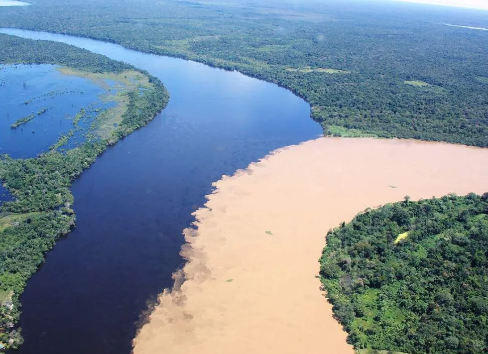
How to look for gold? By golden color. For example, let's remember photographs popular on the Internet where two rivers merge: one with relatively clear water, the other with muddy water. I immediately remember hypotheses about different natural conditions, about coastal erosion, about clay or sandy soil, about mountainous and lowland areas, about different biology, etc.

It looks fascinating. One would like to joke that those looking for oil go to the left, looking for gold to the right. But why make a joke? Let's do just that. Since the article is devoted to the search for gold, we will go to the right.
1. Traveling the Amazon
Let's start with the largest river in the world – the Amazon. There is no need to fly anywhere; Google maps will suffice for us. We start at the mouth and work our way upstream in search of the golden color.
The first fork is where the Tapajos River flows into the Amazon.
The confluence of the Amazon and Tapajos on Google maps You can immediately see that the golden color comes from the west, and not from the south. So we go further west.
The next confluence is not long in coming – this is the Madeira River.
Here we definitely turn south and move on. Along the way we meet the Aripuanan River, which, judging by satellite images, is not much inferior to Madeira, and at the same time strongly contrasts with the golden color. But nevertheless, this does little to dilute the color of Madeira.
Next comes a number of small, medium and large rivers flowing into Madeira. But from a satellite they all look black and blue.
To prevent the article from turning into a set of hundreds of pictures, I will not show all the mergers. However, we must keep in mind that each such merger inevitably dilutes the muddy stream of water that we follow. And since we are going against the current, the reverse process occurs: after each fork, the concentration of muddy water only increases.
And in the end we discover landscapes like this.
The captions under these landscapes are clickable. So if anyone thinks that this is another work of the Impressionists, they can check it themselves. What it is? And this is what I promised: gold deposits. Which are being developed either legally or not. But in any case, they are developed in a very barbaric way. The jungle is cut down, the soil is dug up, all washed out in the nearest river, and all this turbidity from millions of cubic meters of soil flows below. And it’s good if it’s just dregs. With a high degree of probability, there is also mercury (which is actively used to separate gold) and other contaminants (you can read the details, for example, here; or in more detail here). You can read about one of the illegal mining sites here.
2. Travel around Russia
Is there gold in Russia? Let's look. Let's start with one of the largest rivers in Russia – the Lena. Namely, from the place where the Olekma River flows into it. By the way, there are quite a few settlements downstream, including Yakutsk. Where does so much turbidity come from to all these settlements? Gold again? Or this time natural features?
However, we won’t stop at Olekma. Just a few kilometers later the golden trail leads us to the Chara River.
Further, traveling with Google is not so comfortable, so we switch to our native Yandex.
I have a deja vu effect. I have already seen this in South America. I think there is no point in explaining where we are going next.
So, Chara also turned out to be not a source of turbidity, but only its carrier. The Zhuya River is now becoming a suspect. By the way, clean rivers flow into it, but they cannot dilute the turbidity.
But where is the source of the turbidity of the Zhuya River? Going further we find an influx that does not reduce the turbidity, but adds it. According to Yandex, this tributary is called the Great Borokun.
And going up this tributary we find this. Do you recognize? Does it look like South America, albeit on a smaller scale? Further links under the pictures are clickable.
But let's return to Zhue. This small influx clearly produces only part of the total turbidity. We find the next one.
The source of this pollution is the same landscapes. And one of the tributaries of the Southern Marykta, the Omur-Yuryakh, has been so dug up that it is hard to even call it a river.
Let's go further along Zhuya.
Going further against the current, we unexpectedly find a clean tributary of the Zhuya – Khomolkho. It’s a pity that residents of neighboring Perevoz can only get to this clean water by boat.
I think it's time to call it a day. There is a clear excess of pictures in the article. Anyone who wants to can find quite a few more on their own. At the end I will show the place where Zhuya returns to her natural state. But, alas, the dirty Zhuya is being replaced by the even dirtier Vacha
Instead of conclusions
My goal was completely successful: gold deposits were discovered. And in huge quantities too. Yes, they are all known, but I didn’t promise to find deposits unknown to anyone 🙂 However, I don’t get much joy from such finds. Of course, the country needs gold. This means wealth and jobs. But the country also needs clean water. Likewise, residents need clean fish. I really want to hope that our dregs are at least mercury-free, unlike South America.
I have 2 questions that I can’t answer myself:
Are all the digs I found legal?
Do they all meet all standards?
By the way, I only looked at one fragment of the map. There may be many such fragments throughout the country. For example, Vitim also brings a certain dregs to Lena. Anyone who wants can trace its source independently.
Remember the first picture of the article? A beautiful and unusual natural phenomenon. And now in all such pictures I will think “is it natural?” In any case, in the turbidity of Vacha, Zhui, Chara, Olekma, I did not find a single natural source. But there are dozens, if not hundreds, of man-made ones.
What does IT have to do with it (mini-terms of reference “if I were a sultan”)
If we assume a hypothetical situation when they ask me “what to do,” then I would say that first, as for people, you need to make a diagnosis and constantly monitor the state of the body. To do this, you can create something like the following terms of reference (or rather, its concept):
Create a unified database of all deposits, with their area, permitted activities and other information.
Regularly conduct satellite imagery of these deposits and their surroundings. You don't need a large resolution. As practice has shown, a few meters per pixel may be enough.
Using this survey, regularly monitor the color of the water at different points in the rivers.
If there are none, introduce standards for the color of water visible from satellite (banal settling should significantly reduce this turbidity, and therefore help clean the river as a whole)
Scientists pose the problem “is it possible to evaluate the chemical composition of water from a satellite (by spectroscopy or something else)”
Using satellites, monitor violations of the boundaries of permitted activities, as well as identify pockets of illegal mining.
Introduce a system where local residents can report environmental violations.
Well, and of course, regular visits (helicopter flights) to the supervisors’ places.


